Blackcastle House
See also: Blackcastle Estate - Aspects of its History -Peter Connell
Blackcastle House
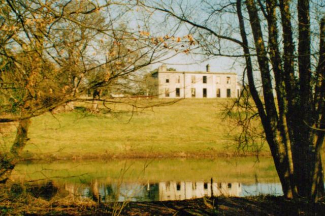
Blackcastle House today stands in ruins on a high spot above the River Boyne close to its confluence with the River Blackwater near Navan.
In 1389 the manor of Blackcastle was granted to John de Stanley by King Richard ll, who in turn granted the manor to the Earls of Ormonde, from whom it eventually passed to the Fitzherbert family. A surviving indenture dating from 1722, records a new settlement between the Duke of Ormonde and William Fitzherbert which granted Fitzherbert and his heirs forever the "Manors and Lordships of Blackcastle".

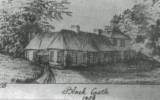
(above) Blackcastle House 1826 by Louisa Beaufort (courtesy of the Irish Georgian Society)
The drawing above shows Blackcastle as a single storey thatched gentleman's cottage to which a 2 storey slated extension has been added. It possibly served as a sporting lodge for the Fitzherberts, who at this time were based in Shercock Co. Cavan.
The 2 storey slated addition was possibly built by the Rev. Daniel Beaufort in 1791 for John Ruxton, the second son of Letitia Fitzherbert, who had inherited Blackcastle after her death. John Ruxton married Margaret Edgeworth in 1770. Margaret was the sister of Richard Lovell Edgeworth, the inventor and educationalist, who in turn was father of Maria Edgeworth, author of Castle Rackrent and other popular novels. Maria Edgeworth often stayed at Blackcastle visiting her "Aunt Ruxton" and cousin Sophia. The following is an extract from a letter she wrote to her mother in Edgeworthstown in 1821:

"How do you do my dear friends, after last night's hurricane? Have any trees been blown away? Has the spire stood? ... The glass dome over the staircase at Ardbraccan has been blown away; two of the saloon windows blown in. The servants in this house sat up all night; I slept soundly. My aunt, roused at an unwonted hour from her bed this morning, stood at the foot of mine while I was yet dreaming; and she avers that when she told me that eight trees and the great green gates were blown down, that I sat up in my bed, and opening one eye, answered, 'Is it in the newspaper, ma'am?' When I came out to breakfast, the first object I beheld was the uprooted elms lying prostrate opposite the breakfast room windows; and Mr Fitzherbert says more than a hundred are blown down in the uplands."
(Edgeworth Papers NLI, MS 25506)
(left) Maria Edgeworth by John Downman 1807
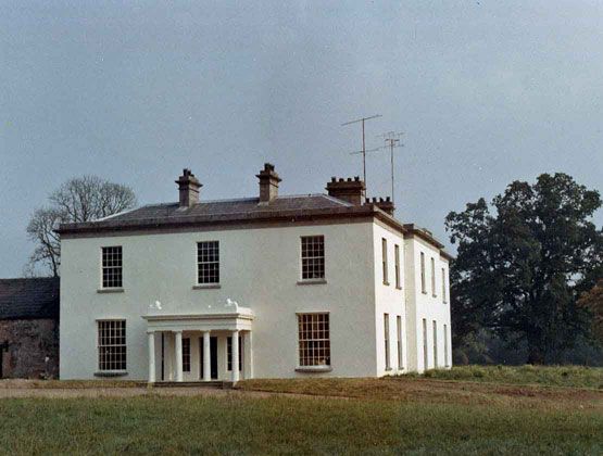
The present house at Blackcastle was completed in 1828 as a six bay two storey building by Richard Ruxton -Fitzherbert. Sir William Wilde in the mid 19th century, described Blackcastle as " a square modern building, designed more for comfort than architectural beauty; but the grounds, which are naturally picturesque, are well laid out and afford many pleasing prospects of woodland glade and sloping meadow".
An estate map for Blackcastle dated 1826, survives, now in the possession of the family of the late Trevor Fitzherbert. At the bottom of the map are lists of all the tenants on the estate. One interesting feature of the map is the use of placenames which are no longer officially recognised, - not making their way into the Ordnance Survey maps of the mid 1830s.
Examples od these old placenames include Clooney (part of Clonmagadden) /Black Hills (also part of Clonmagadden)/ Crockanoar (part of Proudstown) / Lummorog (part of Proudstown) and Mabestown (part of Donaghmore).
The names of tenants in Blackcastle in 1826, include John, Pat and James Melady who held 28 acres between them at Donaghmore; Hugh Powderly of Donaghmore / Matthew McGoonagh also of Donaghmore/ and James Sherlock of Proudstown. In all, apart from the houses and gardens along Pollboy and the land held by Richard Ruxton-Fitzherbert himself, there are 73 separate farms or holdings listed on the map. By far the largest tenant was James Aylmer, who held 255 acres at Proudstown, followed by James Morgan (of Morgan's Mill) who held 88 acres, also at Proudstown.

(above) Blackcastle House before the fire of 1987
In 1940, Blackcastle House was requisitioned by the Irish Army, in anticipation of a possible German invasion, and the Army stayed here until the end of the war. The Fitzherbert family sold the house in 1946, and in the 1960's it was sold again. Throughout the 1980's the house lay empty and abandoned, leading to vandalism and eventually a fire which destroyed it in 1987.

(above ) Blackcastle House - its burned out shell in 2001
*******
Some recent Excavations
Excavations 1999, Summary accounts of archaeological excavations in Ireland, Ed. By Isabel Bennett, Bray 2000.
P235-236
682. Dunmoe, N51 ROAD REALIGNMENT
Close to monastic complex and earthworks. 8848 6977. SMR 25:15. 99E0480.
An assessment was carried out from 23 to 25 August 1999 on four sites identified in the environmental impact statement along the proposed realignment of the N51 road at Dunmoe, Co. Meath. The first of these sites was within the road-take adjacent to the Donaghmore monastic complex (Site A) but within the townland of Blackcastle Demesne.
Site B was also within the townland of Blackcastle Demesne and was identified during a field inspection. It was an oval mound defined by a U-shaped ditch. A third site (Site C), also within Blackcastle Demesne, was earthen-banked, linear feature 0.3 – 0.4m high, running north-east to south-west for c. 20m; this appeared to be a road or pathway. Site D was identified during a field inspection in the townland of Dunmoe and was visible as a circular spread if nettles with a diameter of 9m.
Sites A and D were tested by machine to determine whether archaeological deposits were present. Sites B and C were clearly man-made features and were tested by hand-excavation.
Site A, Blackcastle Demesne
A trench 100m long by 1m was excavated parallel to and to the south of the existing roadway, within the road-take of the proposed road realignment adjacent to the Donoaghmore monastic complex. The trench was excavated to a depth of 0.5-0.6m, to the top of natural boulder clay. Approximately 0.5m from the northern end of the trench a shallow ditch that had been cut into the natural boulder clay was exposed, running towards the road, and represented a relatively modern field boundary. This was indicated on the various Ordnance Survey maps and is not linked with the monastic site. The ditch was c. 2m wide and 0.5 – 0.6m deep. The trench consisted entirely of ploughsoil right down onto the natural boulder clay, indicating that this field had been extensively ploughed in the recent past. No archaeological material was exposed, and no finds were recovered. The proposed road alignment will therefore not affect any archaeological deposits in the area.
Site B, Blackcastle Demesne
This site was identified during field inspections as an oval mound surrounded by a ditch on all sides with the exception of the side next to the roadway. Following the clearing of the vegetation from the site, it became apparent that this feature was a quarry that had been excavated into the side of the hill. Other similar disused quarries occur in the immediate area, some of which are indicted on the Ordnance Survey map. A trench was excavated to the natural boulder clay through the feature and through the ditch alone the south-western side. This confirmed the feature to be a quarry, partially backfilled with material dumped there in the last ten to twenty years. Finds recovered from the mound included mineral cans, whiskey and gin bottles, and fragments of tarmacadam. This feature is therefore not of archaeological significance and appears to be of recent date.
Site C, Blackcastle Demesne
Site C was visible on the ground heading south-eastwards from the present roadway for a distance of 30m before returning southwards towards the River Boyne. A trench was excavated across this feature north-east to south-west within and parallel to the land-take of the proposed roadway. The sod and topsoil came down directly onto the natural boulder clay at an average depth of 0.2 – 0.25m. No archaeological features or material were exposed. This feature is clearly marked as an old field boundary on the Ordnance Survey map. It is of no archaeological significance, and no further archaeological work was deemed necessary.
Site D, Dunmoe
A trench was excavated through a spread of nettles that had been identified as a possible archaeological feature within the land-take of the proposed road. This trench was excavated north-east to south-west and exposed the natural boulder clay at an average depth of 0.15-0.2m below a layer of the sod. A small dump of manure immediately on top of the sod probably accounts for the growth of the nettles. The site is of no archaeological significance, and no further work was recommended.
The excavation of trenches within four sites revealed that there are no know features of archaeological significance along the proposed route of the new road. All four sites proved to be archaeologically sterile, and no further archaeological work is required. Monitoring of the entire toad realignment has been requested by Dúchas.
Donald Murphy, Archaeological Consultancy Services Ltd., 15 Trinity Street, Drogheda, Co. Louth.
********
********
Sources:
Buildings of Meath - a Selection of Protected Structures, Kevin V. Mulligan, Fieldgate Press 2001
Blackcastle Estate, Aspects of its History, Peter Connell, in, Navan, Its People and Its Past, Vol. 1, Journal of the Navan & District Historical Society, 2011 pps.101-113
The Beauties of the Boyne and the Blackwater, William Wilde, pub. Dublin 1849