Moathill & Navan Motte
Moathill & Navan Motte
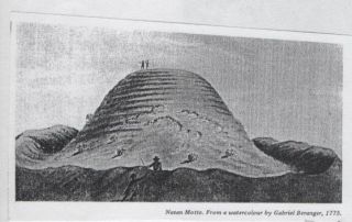
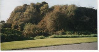
The motte at Navan was the caput (centre) for the Barony of Navan. It was built on top of a natural gravel ridge by Jocelyn de Angulo, the first Baron Navan.
It lies between the old and new Athboy roads opposite Navan Hospital. It differs from Athlumney motte as it was constructed on a gravel moraine and has two fosses or ditches. Athlumney motte has no visible fosses and is sited on a level riverbank. Navan motte is located on the north side of the river Boyne, overlooking its tibutary the R. Blackwater. This is the side most likely to be attacked by the Irish and so it is a much larger motte with more defences. Athlumney motte is on the northern edge of the barony of Skryne and overlooks the Boyne.


There are no roads in this townland ; but the road from Navan to Kells forms its northern boundary, and the road from Navan to Ardbraccan its southern boundary.
Excavations.ie number: 1997:427 License number: 97E0101
Author: Thaddeus C. Breen, 13 Wainsfort Crescent, Dublin 6W, for Valerie J. Keeley Ltd.
An archaeological investigation was carried out along the route of the proposed Inner Relief Road in Navan, where it passed within 70m of the motte known as Navan Moat. Six cuttings, A–F, were excavated along the route. They were 1.5m wide and varied in length from 15m to 30m. In cuttings A, E and F nothing of archaeological relevance was found. In the remaining three cuttings traces of cultivation ridges were found.
Human skeletal remains were found in two cuttings: a skull fragment and tooth in Cutting C, and more substantial remains in Cutting D. The latter were situated at approximately the highest point on a small hillock. The remains of two human skeletons were found, representing a male aged 18–23 and a female aged 31–45. Muscular development and wear on the vertebrae showed the latter to have been accustomed to constant bending and lifting. The skeletons had been disturbed by later agricultural activities, but they appear to have been crouched inhumations, oriented east–west, with the head towards the left. There were no definite grave-goods, but two nondescript pieces of quartz and iron were found.The cutting was widened, but no other burials were found.
*******
p.241.
702. Moathill, Navan. Environs of Motte and Bailey. 28598 26765 SMR 25:23 99E0653
The proposed development site is on the western edge of Navan town, immediately east of an Anglo-Norman Motte and bailey in Moathill townland. The site is along the Athboy Road, close to a sharp, north turning bend, with the motte and bailey dominating the site to the west and the playing fields of a local school to the north. On the south side of the road, directly across from the site, lies and open area of reduced ground level, the result of quarrying and dumping, while the precinct of a hospital lies immediately east of this. Two detached cottages with gardens front the site and there are two large farm outbuildings and remains of smaller sheds in the north-west area of the site, close to the base of the Motte. All existing buildings on the site are derelict, and the west-lying cottage has been burnt out. The garden in front of the western cottage lies at least 1.3m above the road level although there is a gradual fall-off to 0.5m in height of the garden to the east, adjacent to the present access into the site.
On 25 November 1999 four trenches were excavated in the area of the proposed houses. Trench 1 was in the south-west corner of the site, in a garden area west of the existing dwelling. It was excavated in a north-south direction along the line of a series of proposed dwellings c.20m east of the western perimeter of the site. The trench 24m by 1m, was excavated to a maximum depth of 1.3m. Removal of sod (0.2m deep) revealed a homogeneous deposit of grey/brown, sandy clay up to 1.1m deep. Below this the clay deposit contained much natural limestone.
Trench 2 (22.5m by 1m) was in a former garden area immediately west of the access laneway and was excavated in a north-south direction along the line of a series of proposed dwellings. The trench was excavated to a maximum depth of 1.1m, revealing a homogeneous deposit of garden soil 0.4m deep over yellow/brown, sandy clay with occasional rounded stones up to 0.7m deep, lying over natural deposit of compacted stone.
Trench 3 (24m by 1m) was in an area of very overgrown ground north-east of the existing sheds. The trench was excavated in a north-north-east/south-south-west direction from the north east perimeter of the site, along the line of a series of proposed dwellings, to a maximum depth of 1.65m. Removal of brown topsoil (0.3m deep) containing occasional fragments of concrete and brick and stone rubble revealed two extensive dump deposits of black soil contained many early modern finds (bottles, drainage pipe, patterned ceramics, metal hooks, handles, etc.) The two dump deposits, upper 0.2m deep and lower 0.9m deep, were interrupted by a layer of redeposited, coarse, grey, sandy gravel 0.2m deep, containing numerous fist-sized and smaller stones. The lower dump deposit overlay the natural coarse, grey, gravelly clay at a depth of 1.4 – 1.65m.
Trench 4 (34m by 1m) was in very overgrown ground 15m from the north-east corner of the site and was excavated in a north-north-east/south-south-west direction from the north perimeter of the site along the line of a series of proposed dwellings to a depth of 1.9m. Removal of brown topsoil (0.5m deep) containing fragments of concrete, brick rubble and modern rubbish revealed a dump deposit of grey/brown loam including bottles and modern cans 0.14m deep over a tarmac surface 0.06m thick that extended for a distance of 3.2m from the northern end of the trench. Below the redeposited grey/brown loam and tarmac lay a fairly homogeneous deposit of grey/brown, sandy clay 0.7m deep over natural, grey gravel. An extensive dump deposit of early modern rubbish was found cut into the grey/brown sandy clay 17m from the northern end of the trench and extending as far as the laneway to the south. This dump deposit, the same as that encountered in Trench 3, was at most 1m deep, capped by a layer of yellow/brown clay 0.35m thick extending eat and west beyond the trench. The dump deposit contained numerous glass, ceramic, metal and plastic items.
No archaeological stratigraphy was encountered in any of the test-trenches. The presence of extensive early modern dump deposits over most of the north-eastern portion of the site points to ground reduction within this area. From the late 19th century extensive gravel quarrying has been undertaken in the immediate environs of this site, and even the Motte itself has been quarried during the recent past.
Malachy Conway, Archaeological Consultancy Services Ltd., 15 Trinity Street, Drogheda, Co. Louth
Excavations.ie number: 2006:1612 License number: 06E0024
Author: Stuart Halliday, for Arch-Tech Ltd, 32 Fitzwilliam Place, Dublin 2.
Site type: Prehistoric/medieval
ITM: E 685700m, N 767739m
Testing was undertaken by ACS Ltd in January 2006 in advance of construction of the next phase of the Navan inner relief road. The testing was completed under licence 06E0024. Three areas of archaeological significance were identified and Arch-Tech Ltd was commissioned by Meath County Council to undertake full resolution. Site 1 was excavated by Antoine Giacometti under licence 06E0274 (see No. 1611 above). Sites 2 and 3 were fully resolved under licence 06E0024.
The results of the excavation of Site 2 indicated multi-phase activity on the site, with part of two separate enclosures being recorded. Only a portion of each enclosure was resolved, as the remainder continued beyond the limit of the proposed road-take and remains preserved in situ. The first ditch was presumed to be circular in shape and was truncated by a larger rectangular enclosure from which a fragment of bone comb was retrieved. The later ditch is presumed to date to the early medieval period. No definite date was attained for the earlier ditch, but it is possible that it was prehistoric in date.
Of the other features resolved, a kiln and a series of parallel intercutting ditches were excavated at the north-east end of the site but yielded no datable evidence.
Site 3 was located to the south of Site 2 and a number of features of archaeological significance were resolved, including part of a probable prehistoric ring-ditch burial with central cremation pit, two kilns and a probable early medieval D-shaped enclosure, with evidence of two highly truncated circular structures within the confines of the enclosure and two kilns outside the perimeter.
Post-excavation works are currently ongoing and reports will be produced in due course.
1646 Moathill
OS 25:10:4 (29.9, 21.7) Hachured 'Navan Moat' OD 200 N 8598, 6765
Motte and Bailey... Flat-topped earthen mound defined by remains of fosse (diam. of top 15m, diam. of base 37m, H 4.5-6.8m). Small lunate bailey, defined by scarp at NW.
SMR 25:23
OS 42:3:5 (54.6, 49.8) Hachured OD 327, N 7837, 5114
Motte and Bailey
Circular flat-topped mound defined by fosse (diam. of top 16m, diam. of base 46m, H 7.5m). Raised crescent-shaped bailey attached at N by fosse and outer bank (dims. 18m E-W, 7m N-S). SMR 42:5.