Poolboy Bridge
Pollbwee Bridge (Pollboy Bridge)
Ordnance Survey Field Name Book 1835-1836, John O' Donovan
Pollboy, Poll Buidhe, yellow hole or pit. Near the town of Navan.
Pollboy Bridge is built across the Blackwater River, which is here about 130 feet in breadth. It is pictured below with Flower Hill in the background.

This is the oldest bridge in Navan town, and is medieval in origin, the original section probably dating to the 14th century. It was previously known as Navan Bridge and Swyne Bridge. The picture below looks towards Watergate St. and the Inner Relief Road and was taken during the dry summer of 2014. The river is low and the cutwaters can clearly be seen.


(Above) The mid 17th century Down Survey map showing Pollboy Bridge called "Navan Bridg".
 View towards Pollboy Bridge and Fox's old pub before the Inner Relief Road was built. [photo courtesy Mike Jones]
The name Pollboy / Pollbwee is derived from the yellow clay whuch washes down from Flower Hill towards the Blackwater. It carries the R162 across the River Blackwater.
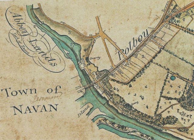
(Above) Pollboy Bridge from Blackcastle estate map early 19th century (courtesy Trevor Fitzherbert)
A recently placed plaque indicates the spot where Thomas Hodgett, the Postmaster of Navan was murdered in February 1921, and from where his body thrown into the River Blackwater.
See: The Murder of Thomas Hodgett, Postmaster in Navan 1917-1921, by Liam McCarthy published in the Journal of the N&DHS, Navan, Its People and Its Past, Vol. 1, 2011, pps 117-132 and also Witness Statement Michael Hilliard Navan Company Irish Volunteers for further information on the murder.